
The following feature is part of a six-month series from Magic Canoe’s Contributing Writers. Four writers were selected to each cover one of four desks – Salmon, New Economies, Environment, and Indigenous Leadership. This story is the third for the Salmon contributor, Tara Lohan. Learn more about our contributing writers here. Major support for the Contributing Writers Series is made possible by a gift from Priscilla Bernard Wieden, in loving memory of Dan Wieden.
A lot more can be gained with sugar than vinegar, believes Jeff Fowle, who is the fifth generation of his family to work the land in California’s Scott Valley, a rural region in the state’s northwest corner. It’s a philosophy that’s led him and other fellow ranchers in the valley to team up with tribes and environmental groups to try to solve the region’s complex water woes.
Historically, it’s an unlikely pairing. The groups have often been at odds over fish, farming, and river management. But things shifted in 2023 with a Memorandum of Understanding between the environmental nonprofit California Trout, the Yurok Tribe, and Farmers Ditch Company, a group Fowle belongs to that collectively diverts surface water from the Scott River for irrigation. In the years since, they’ve undertaken bold restoration projects to resurrect an ailing Scott River, threatened salmon populations, and local economies.
In a part of the country where “water wars” are more common than water wins, the collaboration could help inspire transformative change far beyond their watershed.
A Dwindling River
The Scott Valley sits about forty miles south of the Oregon border and twenty miles west of Interstate 5 in Siskiyou County. It’s dotted by a few small towns—Fort Jones, Etna, and Callahan—that count their populations in the hundreds.
The flatlands, mostly used for ranching and farming, are enveloped by mountains. Hemmed in by the Trinity Alps, the Russians, and the Marbles, the Scott Valley feels geographically isolated. But socially it isn’t. What ties people together here—and what links them to folks hundreds of miles away—is the river.
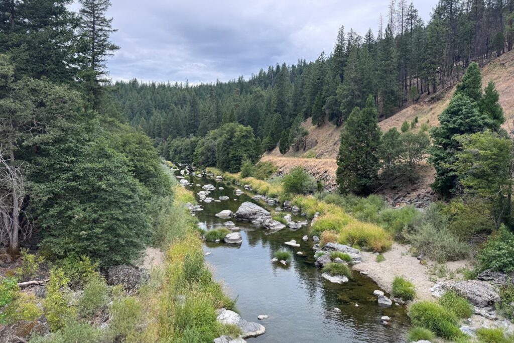
The Scott River leaves the Marble Mountains buoyed by snowmelt. As it flows north for sixty miles, it greens the valley’s pastures, helping to support 25,000 acres of farmland that grow alfalfa, pasture, and grains. The river then narrows through a steep canyon before meeting the Klamath River. This confluence is 143 miles from the Pacific Ocean and the ancestral lands of the Yurok people. More than a century ago, the Klamath watershed hosted some of the largest salmon runs in the contiguous United States, which supported commercial fishers, and the health, culture, and food sovereignty of numerous tribes.
But dams, water diversions, and development pushed many of those salmon populations perilously low. Four dams removed upstream on the Klamath River in 2024 aim to restore salmon runs, but more work is still needed, including in major tributaries like the Scott. Of particular concern is the Southern Oregon-Northern California population of coho salmon, which are listed as threatened under the Endangered Species Act. The Scott River remains a vital refuge for them, with half of California’s wild coho hailing from the river.
That foothold, however, is tenuous because the Scott itself is imperiled by low flows that can leave parts of the river dry at times. Drought, climate change, land use, and water diversions all sap the river’s flow, obstructing fish passage and degrading habitat.
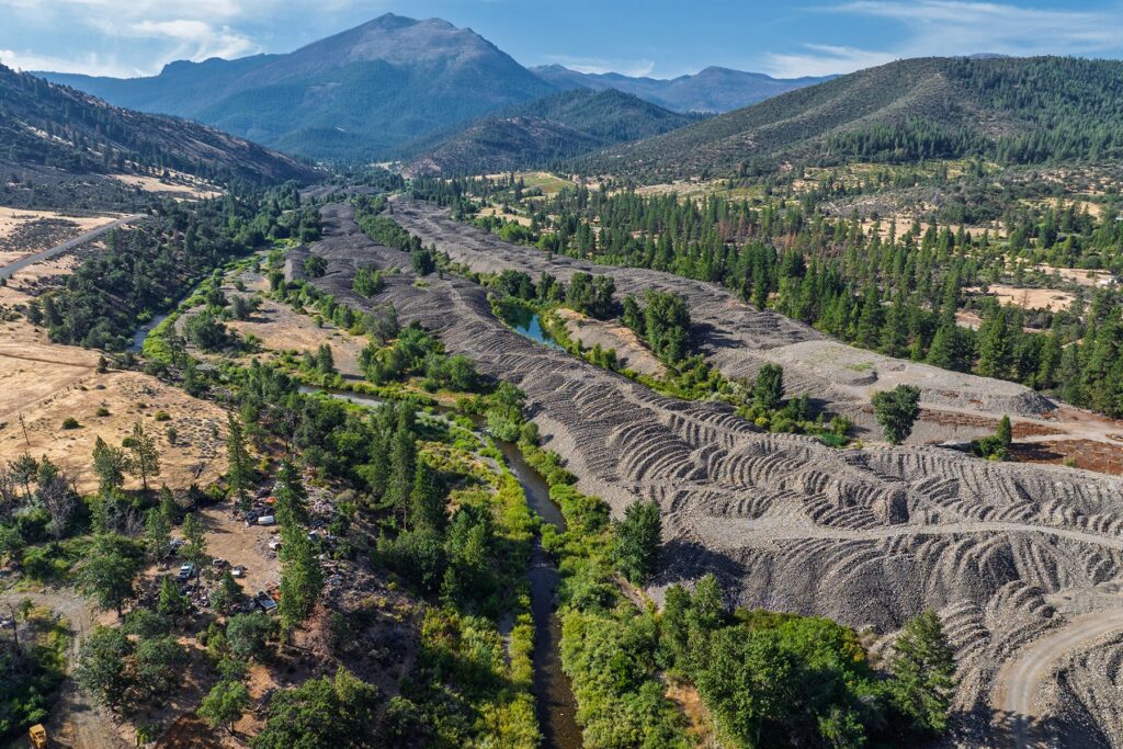
The legacy impacts from gold mining are another hurdle. Prospectors struck gold in the watershed in 1850. By the early 1930s, Yuba dredges, massive machines that floated in the water as they dug fifty feet to scoop up the earth, were busy in the Scott River. The tailings, stripped of their precious metals, were dumped in huge scalloped linear mounds twenty-five feet high and stretching nearly five miles along the river.
The process, which went on until the 1950s when the company skipped town, turned the riverbed upside down. It left large cobbles on top and fine sands buried underneath, destroying the floodplain and altering the flow and function of the river. A veritable moonscape remains.
“These are now geologic features,” says Michael Belchik, a senior fisheries biologist with the Yurok Tribe. “No flood is ever going to remove them. They’re there for eternity, unless you do something about it.”
In summer months, this stretch of river becomes disconnected. The river flows hit the porous cobbles and disappear underground for more than a mile. “During summer, this dry reach functions much like a seasonal dam. When the river disappears into the mine tailings, it cuts off roughly a quarter of the Scott River’s cold-water tributaries from the lower river, blocking both upstream- and downstream-migrating salmon and other native fish,” says Damon Goodman, the Mount Shasta-Klamath regional director for CalTrout.
That’s detrimental for coho, which like clear, cold streams for spawning and rearing. “Coho are a focal point species for our work here, but our goal is to restore a functioning river for the entire native fish community—including Chinook salmon, steelhead, Pacific lamprey, and other native species,” says Goodman. Chinook, which migrate upstream to spawn in early fall when flows are at their lowest, often can’t reach their spawning habitat in the Scott.
“You don’t have to have a fishery degree to understand that if they can’t reach their spawning grounds, then they’re not going to spawn there, and then the fish will just die out in that area,” says Belchik.
Building an Alliance
With low summer flows in the Scott and salmon on the ropes, the State Water Resources Control Board—after legal challenges from the Karuk Tribe and the Environmental Law Foundation—issued an emergency declaration in 2021 to curtail irrigation diversions from the river to maintain minimum flows for ecological health. In the years that followed, curtailments for surface water have largely remained in place, although the regulation allows irrigators to pump groundwater if they reduce their usage by 30 percent during the irrigation season.
There are two main surface water diverters in the valley. The Scott Valley Irrigation District withdraws water at the Young’s Dam to irrigate three thousand acres along a fourteen-mile ditch. And Farmers Ditch Company maintains an irrigation canal that funnels water to nine property owners who irrigate a thousand acres of farmland. Both were hit hard by the curtailments, but Farmers Ditch had an additional problem: an unstable point of diversion.
Arguably the most critical piece of infrastructure on an irrigation ditch is the point where water is diverted from the river into the ditch. In 1964, a flood destroyed the concrete diversion structure used by Farmers Ditch. They rebuilt with a less high-tech design: a gravel push-up dam. It’s as simple as the name suggests: Rocks in the river are pushed up to block the channel, usually with an excavator or another machine. But the gravel dam frequently washed out in high flows and wasn’t too friendly to fish. In the 1990s, California’s Department Fish and Wildlife offered to create a new structure for Farmers Ditch with some added benefits for fish. That one didn’t last long either, washing out in a flood not long after it was built.
Farmers Ditch scrambled to rebuild their diversion point yet again, but the new iteration didn’t have a fish screen at the river. Instead, it was a quarter mile up the ditch, and fish frequently strayed into the canal and became stranded when the flows were halted, or swam out the bypass and ended up in the dry section of the tailings reach. Neither situation worked well for fish, and state and federal fish agencies put pressure on Farmers Ditch to solve the issue. The irrigators, on the other hand, believed the state should be responsible for this fix. For years, they remained at an impasse, with fishing losing out.
But, as it so often happens, a crisis creates an opportunity.
“I have seen a lot of attempts to fight the government, and the only people that come out ahead at the end are attorneys,” says Fowle. Instead, the Siskiyou Farm Bureau, of which Fowle was director at the time, opted for collaboration.
They reached out to the Yurok Tribe and asked if they could introduce them to ranchers in the Scott Valley. The tribe agreed. “This is in keeping with our strategy that we would rather work with people and figure out how we’re going to live together, rather than just fight forever,” says Belchik. “We believe working with agricultural partners to bring up sustainable agriculture and fisheries at the same time is really the only way forward.”
Some initial meetings took place in 2022, and conversations led to relationships and the forging of common ground. “Agriculture and the tribes, we all want fish to be plentiful, and we believe that working together, we can solve this problem,” says Fowle.
In June 2023, the Yurok Tribe, Farmers Ditch Company, and California Trout signed a Memorandum of Understanding that sought to make the Farmers Ditch diversion a reliable and secure water source, while also fish-friendly. Additionally, the group agreed to improve fish habitat in the tailings reach. They moved from idea to action when they secured a $7 million grant from the state.
A partnership with agriculture, an environmental group, and a tribal nation marked a stark departure from years past in the region. “At times, discussions about water and fish became extremely contentious. The change today is that people who once saw one another as opponents are now sitting at the same table and solving problems together,” says Goodman.
Instead of focusing on trying to take away something—limiting water rights or blocking fish passage—folks talked about how they could help each other solve the problems they faced. And those problems affected the entire watershed, from the headwaters above the Scott Valley where the farmers live, to the Klamath’s mouth in the Yurok Tribe’s ancestral lands.
“Regulation establishes important protections and plays a critical role, but durable solutions to complex problems can also be developed locally and collaboratively,” says Goodman. “This approach depends on a foundation of trust. Once that trust exists, funding and technical expertise can help turn shared ideas into outcomes that work for fish, farms, and communities.”
The Solution
Their innovative approach is already beginning to pay off. Crews got to work on the project in 2025, completing the first phase of restoration and improvements.
“The central question is: How do we provide a more reliable water supply for agriculture, make the diversion safe for fish, improve the habitat around it, and reconnect flow in the river at the same time?” asks Goodman.
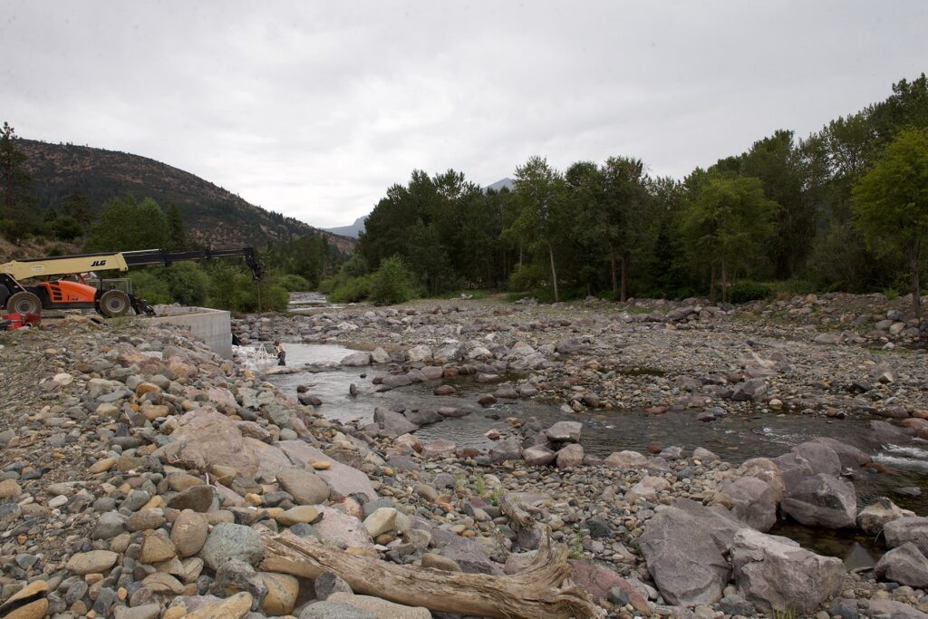
A new concrete diversion structure for Farmers Ditch sits along the riverbank now, with a large cone screen to prevent fish from taking a wrong turn into the ditch. Workers this summer are busy putting on the finishing touches, including a modernized water-control system so irrigators can remotely operate the diversion and precisely measure the water entering the ditch. It’s a big upgrade from the gravel push-up dam.
The area where the work is taking place is right in the stretch of river where the mounds of tailings have impaired the river’s flow—and it’s also the confluence of the Scott River and Sugar Creek, an important tributary for salmon.
“This is in keeping with our strategy that we would rather work with people and figure out how we’re going to live together, rather than just fight forever.”
Michael Belchik
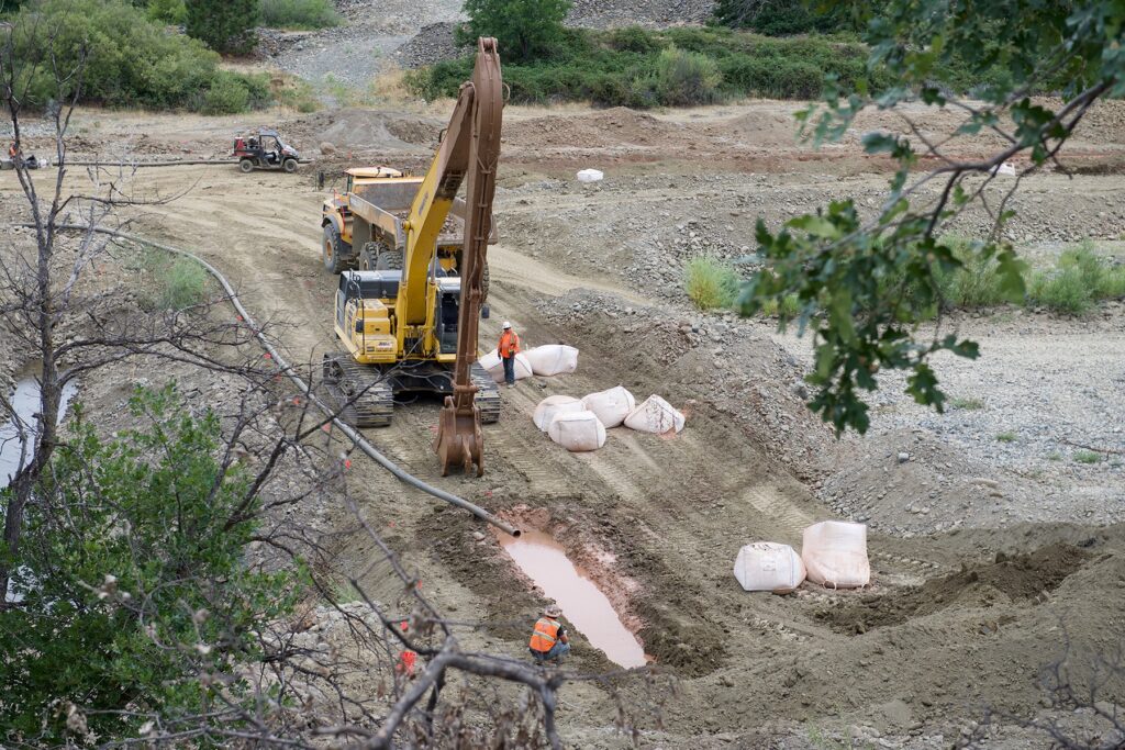
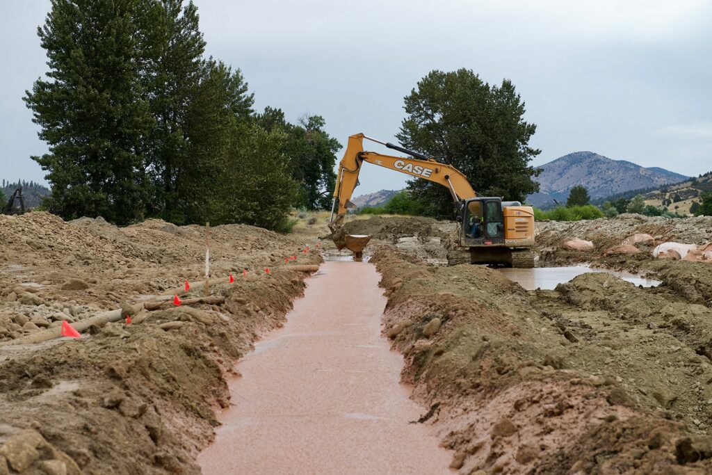
To ensure a reliable flow of water making it into the ditch, and to improve passage up the Scott and Sugar Creek, the Yurok Tribe Construction Corporation has been moving tons of rock. They’ve pushed away some of the tailings to give the river more room, reconnecting the floodplain, and creating a three-hundred-foot-long “roughened channel.” It’s an engineered effort that places natural rock structures in the river. To the untrained eye, it looks like a rocky stretch of river, but the strategic placement of boulders and other rocks helps direct water flows to allow fish to swim upstream and downstream during different flow conditions, and ensure a depth of water for the Farmers Ditch intake.
Another component to the work in this reach of the river requires more technical engineering. This summer, crews are building a “hyporheic” control structure: When water starts to go underground at the tailings reach, it will hit a slurry of bentonite clay, forcing the water back up to the surface of the riverbed. Because this approach is a pilot, partners will closely monitor groundwater, surface flow, water temperature, and downstream habitat.
When this phase of the project is completed later this summer, partners hope it will help coho, chinook, and other fish to pass through these dried-out river sections and more often reach cold-water streams like Sugar Creek, South Fork Scott River, East Fork Scott River, and other upstream tributaries.
“Historic dredge mining fundamentally altered this reach of the Scott River, creating a substantial and persistent challenge,” says Goodman. “This project is among the first river-restoration efforts to look below the riverbed and directly address the subsurface processes that influence surface flow and habitat. It is an innovative approach at the leading edge of restoration science.”
So far, the restoration work has taken place in a half-mile stretch of the tailings reach, but nearly four more miles remain impacted and project partners hope to tackle more of it.
“This is the most promising approach we have identified for restoring the seasonal surface flow connection issues through this reach,” says Goodman. “If monitoring shows that it works as intended, it could provide a model for restoring the remaining tailings reach and inform similar efforts on mine-impacted rivers elsewhere.”
The work makes a dent in the environmental destruction caused by the dredges, but it doesn’t yet come close to completely remediating it.
“Mining has permanently changed the river,” says Belchik. “But with our restoration, we can alter the river channel and have the river display more characteristics of a healthy river, the ability to meander and actually have a floodplain.”
The Big Picture
A healthier stretch of river through the mine tailings reach helps to amplify other restoration efforts in the watershed, of which there are many. The Scott River Watershed Council has been working for years to build structures that mimic beaver dams in Sugar Creek. Before mining altered the landscape, trappers from the Hudson’s Bay Company cleared the area of beavers, which were once so numerous the valley was called Beaver Valley.
Beaver dam analogues help to bring back some of the ecological benefits that beavers have on the landscape, including slowing down water to recharge groundwater, filtering sediment, and creating deep pools favored by young coho. The new roughened channel at the confluence of Sugar Creek and the Scott River now helps fish more easily reach these structures and the habitat they create.
Farther upstream, CalTrout, the Scott River Watershed Council, and the Karuk Tribe are doing additional restoration work in the Beaver Valley Headwaters Preserve, a six-thousand-acre property recently owned and managed by Wildlands Conservancy for conservation, public use, and education. These projects will be done in the East Fork Scott River, Big Mill Creek, and Noyes Valley Creek—all in the Scott River watershed. Efforts will focus on constructing beaver dam analogues, creating side channels and alcoves for salmon habitat, installing large woody debris structures, and reconnecting the floodplain to improve the river’s natural functions.
Elsewhere, individual landowners, like Fowle, are also contributing. He has engaged the Karuk Tribe and Yurok Tribe on two restoration projects where the Scott River passes through his land that will help improve habitat and also limit sedimentation. And two of his neighbors are embarking on similar efforts.
It’s a sign of the times in the Scott Valley where collaboration is slowly replacing conflict—and where local economies, Indigenous communities, native fish, and the entire watershed benefit.
“We’re all on the same page now. We may have different ideas of how to get to where we want to go, but our objective is that we want a healthy community from the headwaters to the ocean,” says Fowle. “If I can stay in business and my son can stay in business and tribes can stay in business, they can fish—and we [don’t] negatively impact the birds, the amphibians, the terrestrials—then that’s a healthy community.”