This feature is part of a six-month series from Magic Canoe’s Contributing Writers. Four writers were selected to cover one of four topics: Salmon, New Economies, Environment, and Indigenous Leadership. This story is the first for the Environment Desk. Meet our contributing writers here. Major support for the Contributing Writers Series is made possible by a gift from Priscilla Bernard Wieden, in loving memory of Dan Wieden.
From the top of Vedder Mountain, a rocky bump in southwestern British Columbia’s North Cascade Range, you can see all of Sumas Prairie. It looks like a misshapen checkerboard: green, brown, and yellow farm fields carved into rectangles by roads, dikes, and canals.
Look closer and you’ll see what it used to be—two mountains, with Vedder to the north and Sumas to the south, rising like the sides of an old cauldron. To the east and west, canals and dikes zigzag across the land, and together, they trace the lost shorelines of a lost lake.
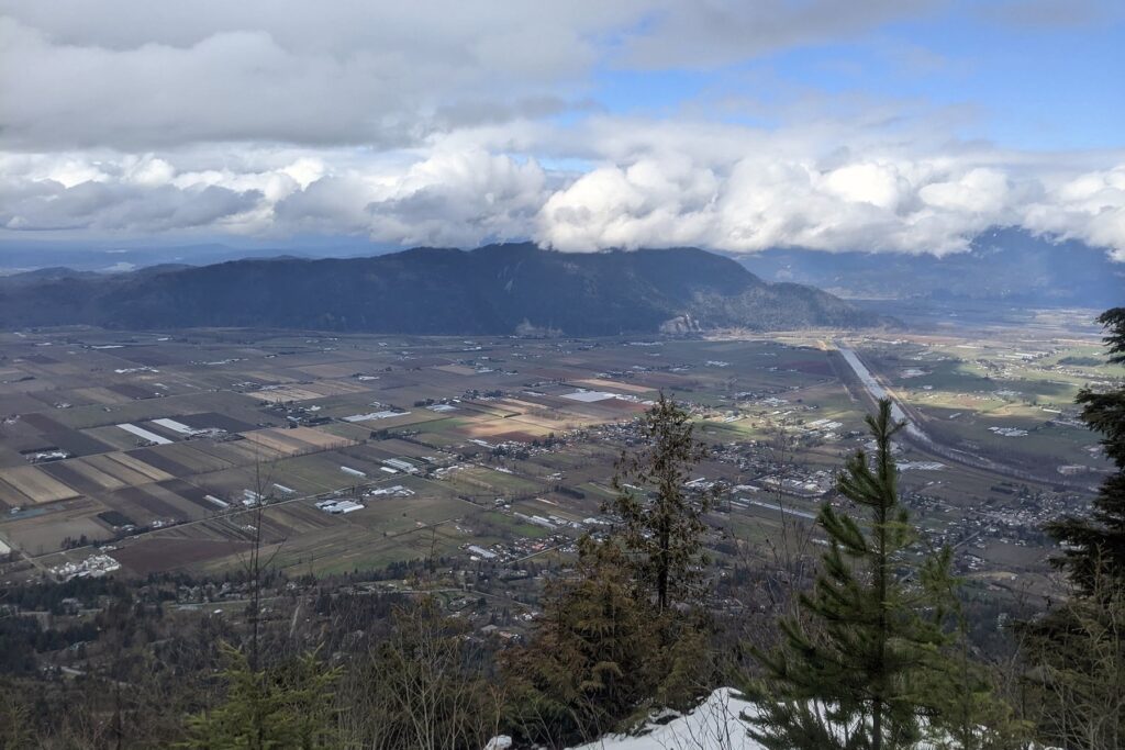
When the first European fur traders arrived, they called this 10,000-acre body of water Sumas Lake. It was a mispronunciation of Semá:th, the name of the Indigenous nation who had lived along the lake’s shores for generations. The nation still calls it Semá:th Xó:tsa. The lake was wide and shallow, and when it swelled with spring snowmelt, it could triple in size. You can still see it on old maps, a part of the Lower Fraser River watershed that stretches from modern-day Hope, B.C., to the Pacific Ocean.
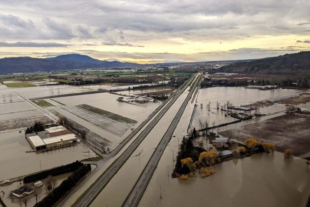
In 1924, the lake was drained to make way for settlement and farming, but when a series of climate-driven “atmospheric rivers” hit the Pacific Northwest in November 2021—meteorological events where warm, saturated air delivers weeks’ worth of rain in a matter of hours—the landscape flooded. Suddenly, from Vedder Mountain, it looked like the lake had returned.
Riley Finn wasn’t surprised by the flood. He works at the University of British Columbia’s Conservation Decisions Lab and had been working with researchers, conservationists, and First Nations since 2017, examining flooding and conservation issues in the Lower Fraser River watershed.
“We had been meeting and discussing this kind of problem for a few years when the floods happened in 2021,” Finn explained. “We were well placed to think about Sumas Lake within a historical context, and to think about the broader future of the region from that perspective.”
Three years later, Finn, a group of researchers, and local First Nations published a study about how restoring Semá:th Xó:tsa could help manage local flooding. They proposed a First Nation–led program to purchase lands in the old lake bed and to start letting the water return. The proposal combined ecosystem restoration with an idea called “managed retreat.” Coined by coastal engineers dealing with sea level rise in the 1990s, managed retreat has become shorthand for relocating people and infrastructure from flood plains, disappearing coastlines, drought-stricken regions, or other areas responding to climate change.
“Water Back, or in this case ‘Lake Back’ . . . can be part of an integrated and inclusive approach to managing flood risks,” the paper explained. “. . . [M]anaged retreat offers a solution to climate change-induced flooding, allowing floodwaters a place to go and potentially mitigating their downriver impact.”
For a century, people had been keeping the water out of Sumas Lake, but this 2024 report proposed working with instead of against the land. One of the authors, Ned Murray, executive director of the Lower Fraser Fisheries Alliance and a member of the Semá:th Nation, described it as “harmonizing with the water.”
A Tale of Two Food Systems
Sumas Prairie, the former lake bed, is now flanked by gravel-topped dikes that track its former shorelines. Water flows lazily through the canals and ditches. Great blue herons perch in the flow. Songbirds dart from berry bushes. A few hardy stands of wild blueberry remain, but most are invasive Himalayan blackberries, a plant that thrives in what scientists call “disturbed areas.”
Before the lake was drained, it was the heart of the Semá:th food system. Its waters were thick with trout, sculpin, and salmon. And while every species of Pacific salmon lived in the lake, the waters were most known for white sturgeon. Sometimes called “living fossils,” these pale-gray sturgeon lived alongside dinosaurs. When the lake was drained, the story goes that farmers found some of these ancient fish still living in the mud.
The Semá:th also harvested ducks and geese along the shoreline, too, and hunted elk and deer that traveled through the valley. They gathered blueberries, wild strawberries, hazelnuts, roses, and wapato, a wild potato that thrived in the sandy soil. Ironically, the destruction of this abundant food system made way for the expansion of a modern agricultural system.
“People point out that food security is something that’s in mind, with the richness of farmland underneath [the lake],” Semá:th Nation chief Dalton Silver said back in 2021. “Initially, it was food security for our people. Now, with the lake gone and the farmland there, that provides food security for a great number of people.”
The change from an Indigenous food system to modern farms began in 1878, when British Columbia passed the Sumas Dyking Act. After British Columbia had pushed First Nations in the Lower Fraser watershed onto three reserves: the Upper Sumas Reserve near Sumas Mountain, the Aylechootlook Reserve near the Sumas River, and the Sumas Cemetery Reserve, a small parcel of land near the lake.
The rest was given to settlers who struggled to deal with spring floods. In the summer, they would complain about mosquitoes swarming the lake, something the Semá:th dealt with by moving onto seasonal stilt houses where the valley winds kept the bugs away. Residents of the province described the floods and bugs as putting the land into “a state of comparative unproductiveness.” They didn’t have a plan for it yet, but they suggested that draining the lake could be an option.
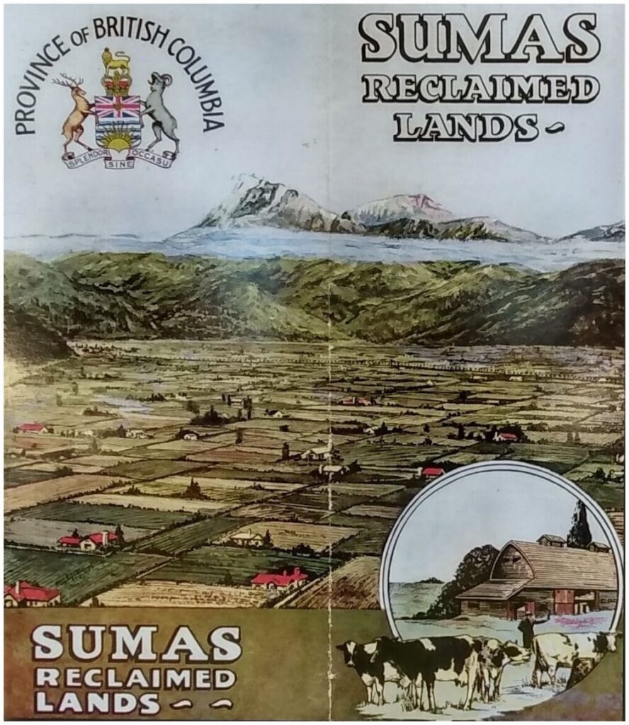
A few dikes were built in the years that followed—but floods kept coming. The province passed more legislation in 1892 and 1893, to expand the dikes. A historic snowmelt flooded the valley in 1984, leading an engineer named Frederick Sinclair to make a plan to drain the lake. Called the Sinclair Plan, it was approved in 1918 and, by 1924, the water was gone. The Semá:th were never consulted.
“It is something that our people never would have even thought of doing, altering nature in such a way.”
Chief Dalton Silver
In 2020, the Reach Gallery Museum, a cultural center in Abbotsford, B.C., published a children’s book called Great Gramma’s Lake. It tells the story of Semá:th Xó:tsa before it was drained, when a village called Texqeylstood on either side of the channel connecting the lake to the Fraser River.
“This was a place for warriors, stó:méx,” the book explained. “Sometimes people would travel from the coast to raid our villages. The rock bluffs on the mountain were lookouts for the stó:méx. When they spotted the invaders, they would use fires or smoke to send warning signals upriver.”
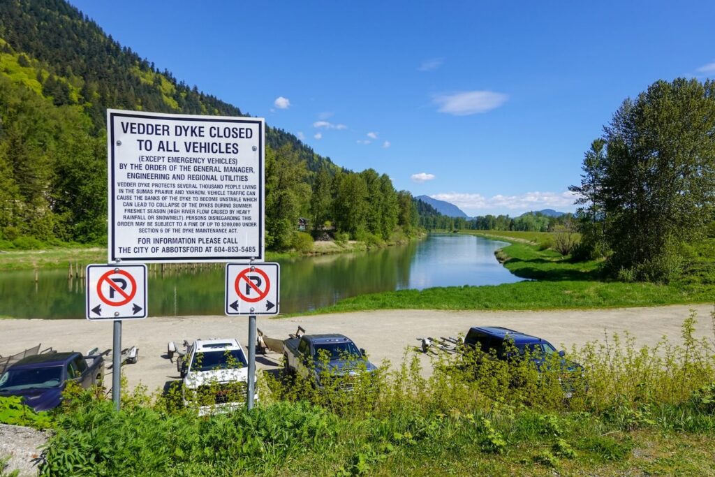
The village is gone, but one of the last redoubts of the lake remains: the Sumas Lake Canal. What was once the lake’s northern reach is now a narrow strip of aquamarine wetlands. Near the middle is the Barrowtown Pump Station, a concrete and steel structure built in the 1980s to replace the pumps that Sinclair used to drain the lake.
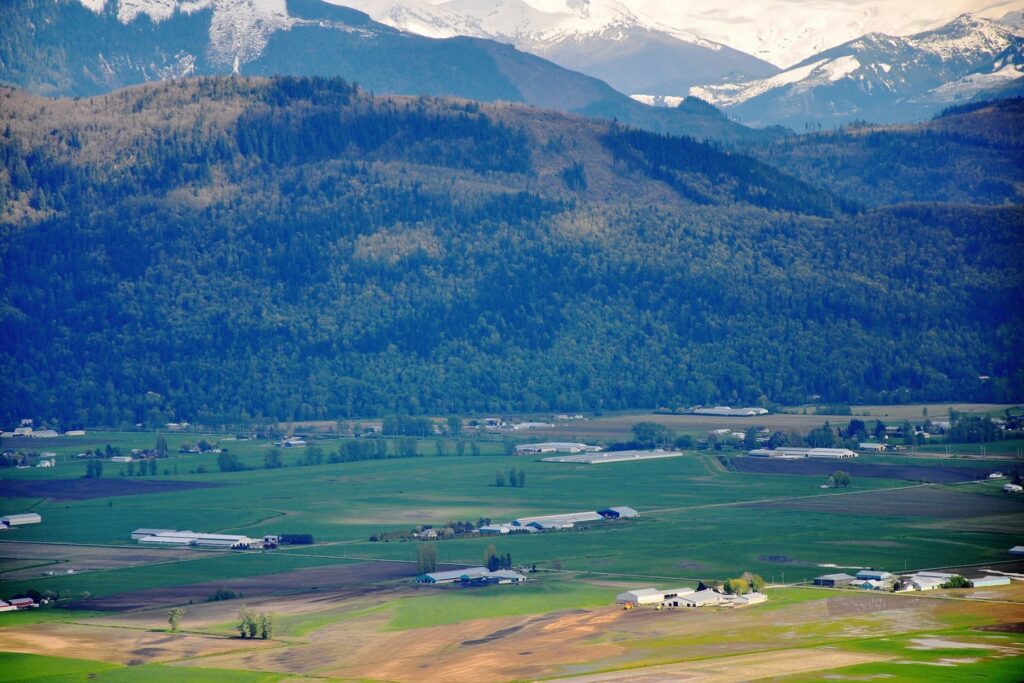
South of the station, across four lanes of highway, is farmland. According to the City of Abbotsford, it puts food on half the plates in British Columbia. In 2024, the city’s communications director, Aletta Vanderheyden, told The Narwhal that local agriculture was responsible for 16,770 jobs and $3.83 billion in revenue. “Reflooding Semá:th Xó:tsa would mean losing that premium agricultural land and would significantly impact our provincial food supply.”
Less than two years after she made those comments, the lake returned again. On December 11, 2025, the Nooksack River’s North Cedarville gauge hit more than 150 feet, nearly a foot higher than the record set in 2021. Water started pouring north, overwhelming the pumps and dikes.
“A lot of these structures were built [before we were] considering sizing them for climate change,” said Lina Azeez, Habitats Program Director at the Watershed Watch Salmon Society. “They get overwhelmed with the amount of water that’s coming down all at once.”
Letting the River Do the Work
These flooding events of 2021 and 2025 weren’t the first times that the Nooksack River made it into Canada. In the 1970s, geologists working on Sumas Prairie discovered deposits of Baker andesite. Scientists used the rock forged in the volcanic heart of Koma Kulshan—the Indigenous name for Mount Baker—to track volcanic activity. The rock in Sumas Prairie was too recent to have come from an eruption. The only way it could have traveled 25 miles north was as sediment in the North Fork of the Nooksack.
Today, the river flows solely through the United States, but when it floods, the water pours north, inundating low-lying border towns and filling the old lake bed. Managing this is a challenge; preventing floodwater from reaching Canada will increase downstream flooding in Washington, but installing more dikes and hardening the riverbanks in the United States will push more water north.
Indigenous, municipal, regional, provincial, and state governments on both sides of the border recognized this challenge when they signed on to what’s called the Collaborative Transboundary Flood Management Framework in October 2023. This agreement became the Transboundary Flood Initiative, a collaboration that aims to mitigate cross-border flooding while pursuing ecological restoration and “incorporating Traditional Ecological Knowledge into solutions where appropriate.”
The initiative gave an update on their progress in March 2026. It included a habitat assessment of parts of the former lake led by the Semá:th Nation and the Nooksack Tribe. There was also an update about replacing a culvert along the Nooksack River in northwestern Washington, and a plan for flood mitigation in Whatcom County. Flanked by the North Cascades and the Pacific, the county is home to Bellingham, the Mt. Baker ski area, and the three forks of the Nooksack River. The county released a series of plans to manage sediment and flooding on the Nooksack, including one to “Widen the Funnel,” by expanding the river corridor and letting the river “do the work.”
“This could include constructed side channels, engineered logjams to promote deep pool formation and hydraulic complexity, riparian reforestation, and other constructed features to ‘jumpstart’ habitat benefits,” the plan explains.
It’s the kind of nature-based flood mitigation plan that Azeez thinks the region needs more of. “One of the most powerful things we can do is reconnect rivers to portions of their flood plain, allowing water to spread out during high flows, reducing downstream flood peaks all while creating valuable habitat for fish and wildlife,” she said.
But Whatcom County’s plan isn’t the only one in the watershed. About an hour’s drive west of Sumas Prairie, the Katzie First Nation has been leading work to restore Xwíʔləm̓nəc, or Addington Point Marsh. Much like Semá:th Xó:tsa, the lands around Xwíʔləm̓nəc were diked and drained in the 1800s to make way for agriculture. Before that, the marsh was home to wild salmon, birds, and medicinal and edible plants. But unlike the lake, water is coming back into the marsh. The Katzie First Nation, supported by government and conservation groups, has started to reconnect the marsh to the Pitt River, a major tributary of the Lower Fraser. They’re restoring habitat to create a natural wetland flood buffer.
“It’s all about restoring relationships. You’re restoring the relationship between the river and these wetlands that were formerly alienated by dikes. You’re restoring the relationship between Xwíʔləm̓nəc and juvenile salmon that previously were prevented from accessing the site . . . it’s also restoring the relationship between Katzie and their kin.”
Eric Balke, Ducks Unlimited senior restoration biologist
A “Long, Hard Process”
There’s one main difference between Xwíʔləm̓nəc and Semá:th Xó:tsa, and that’s homes. Sumas Prairie is covered not just by fields and buildings, but also family homes and a hundred years’ worth of memories and legacy.
Neil Smith, who lived on Sumas Prairie and passed away in 2015, talked to reporters with the Vancouver Sun about his life there. He told them that he had moved there in the 1930s, when he was five years old.
“We used to plow up big freshwater clam [shells],” Smith said. When asked about selling his land, he told the reporters that he wouldn’t trade it for anything, a sentiment echoed by the City of Abbotsford.
“As a municipality, our responsibility is to ensure that our community infrastructure protects our community and our residents, which is why we are focused on flood protection measures and are not considering reflooding options,” said Vanderheyden, the city’s communications director.
But Vanderheyden says that work is proving challenging. “Without funding support from the federal government, Sumas Prairie, along with our provincial food supply and some of the country’s most critical trade and energy infrastructure, remains vulnerable,” she explained.
And just because Abbotsford isn’t publicly talking about bringing back the lake doesn’t mean conversations about it aren’t happening. In 2023, the Semá:th,Leq’á:mel, and Máthxwi Nations entered into an agreement with Abbotsford, Chilliwack, and the province of B.C. to explore solutions to flooding in Sumas Prairie. The collaboration agreement included a commitment for all parties to “recognize the history of Semá:th Xó:tsa” when considering solutions to “highly variable and extreme flood conditions.”
Conditions that climate scientists with the U.S. Department of Agriculture’s Northwest Climate Hub expect to worsen as climate change drives the number of atmospheric rivers hitting the region. They also expect those atmospheric rivers “to be bigger and more hazardous.”
Semá:th chief Dalton Silver thinks this will mean some landowners in the former lake bed could be more willing to sell their land. If enough do, theSemá:th might be able to use that land to bring back the lake. Silver described it as a “long, hard process,” especially because, for the nation, “our idea is not to kick people out of their homes.”
“Sometimes you need to come up with what seems like a very extreme idea, and then it slowly socializes and becomes something that everybody starts to understand.”
Lina Azeez, Habitats Program Director at the Watershed Watch Salmon Society
But Riley Finn worries that some people will still dig in and support the status quo. “Our changing climate presents a challenge to engineering our way out of this because that relies on predicting future weather and flood events,” he said. “[But] adopting more of a nature-based solution, you approach a different relationship to the problem and the risk associated with it.”
For Azeez, the fact that conversations about restoring Semá:th Xó:tsaare even happening is reason to be optimistic. “Sometimes you need to come up with what seems like a very extreme idea, and then it slowly socializes and becomes something that everybody starts to understand,” she said. The question now is just how many floods might it take for that understanding to eventually break through.